Difference between revisions of "File:AJ2011111217322M.jpg"
Jump to navigation
Jump to search
(Importing image file) |
|||
| (One intermediate revision by one other user not shown) | |||
| Line 1: | Line 1: | ||
| + | Map of contamination after the [[Fukushima disaster]] reported by [[Asahi Shinbun]] for |
||
| − | Importing image file |
||
| + | 2012 November 11 |
||
| + | <ref> |
||
| + | http://ajw.asahi.com/article/0311disaster/fukushima/AJ2011111217258 |
||
| + | Radioactive cesium spread as far as Gunma-Nagano border. |
||
| + | November 12, 2011. |
||
| + | (for year 2018, the link fails) |
||
| + | </ref>. |
||
| + | |||
| + | The image is owned by the [[Asahi Shinbun]], |
||
| + | For the commercial use, communicate Aasahi. |
||
| + | In any case of use, the source should be attributed. |
||
| + | |||
| + | ==References== |
||
| + | <references/> |
||
| + | |||
| + | [[Category:Fukushima disaster]] |
||
| + | [[Category:Asahi Shinbun]] |
||
| + | [[Category:Nuclear accident]] |
||
| + | [[Category:Map]] |
||
| + | [[Category:Japan]] |
||
Latest revision as of 16:14, 28 December 2018
Map of contamination after the Fukushima disaster reported by Asahi Shinbun for 2012 November 11 [1].
The image is owned by the Asahi Shinbun, For the commercial use, communicate Aasahi. In any case of use, the source should be attributed.
References
- ↑ http://ajw.asahi.com/article/0311disaster/fukushima/AJ2011111217258 Radioactive cesium spread as far as Gunma-Nagano border. November 12, 2011. (for year 2018, the link fails)
File history
Click on a date/time to view the file as it appeared at that time.
| Date/Time | Thumbnail | Dimensions | User | Comment | |
|---|---|---|---|---|---|
| current | 17:50, 20 June 2013 | 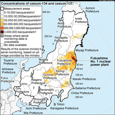 | 375 × 375 (156 KB) | Maintenance script (talk | contribs) | Importing image file |
You cannot overwrite this file.
File usage
The following 6 pages use this file: