File:Mapa-poshyrennya-radiatsiyi-u-vypadku-avariyi-na-ZAES-840x441-c-1.jpg
Summary
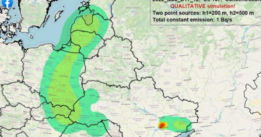
Qualitative simulation of advection of puff under the conditions observed on 2022 August 15–18, in the event of an accident at the Zaporizhia Nuclear Power Plant. Map by rubryka [1]
Original filename: https://rubryka.com/wp-content/uploads/2022/08/Mapa-poshyrennya-radiatsiyi-u-vypadku-avariyi-na-ZAES-840x441-c-1.jpg
Description
13:56 18 AUG 2022
Ukrainian scientists modeled radiation spread map in case of accident at Zaporizhzhia NPP. Under the conditions observed on August 15–18, in the event of an accident at the Zaporizhia Nuclear Power Plant, radioactive contamination would primarily affect Ukraine
The Ukrainian Hydrometeorological Institute reports this.
However, as the scientists note, the radiation would also affect the neighboring states: pollution would threaten Kyiv and Donbas's occupied territories.
Researchers of the Ukrainian Hydrometeorological Institute of the State Emergency Service of Ukraine and the National Academy of Sciences of Ukraine performed a simulation of the transfer of radioactive impurities during a hypothetical accident at the Zaporizhzhia NPP (ZNNP) under meteorological conditions on August 15–18, 2022.
The results of modeling the atmospheric transfer and dispersion of Cs-137 radioactive aerosols were obtained using the WRF ARW v4.3 forecast meteorological model and the atmospheric dispersion modeling complex CALMET-CALPUFF v6.
Scientists calculated the WRF forecast of meteorological conditions based on GFS global forecast data with a spatial resolution of 0.5o and a time resolution of 3 hours.
Radioactive emissions are given in the form of two-point sources at 200 and 500 m above the earth's surface with a total stationary power of 1 Bq/s (0.5 Bq/s for each source).
Scientists used the characteristics of their size distribution for radioactive aerosols: average diameter one μm, standard deviation two μm.
Due to the impossibility of determining the exact characteristics of the source of emissions in the event of a hypothetical accident at the ZNPP, we should interpret the results of numerical modeling only qualitatively and relatively.
"According to the results of the calculations, during August 15–18, 2022, the highest concentrations of radioactive aerosols can be observed within the territory of Ukraine, especially in the near zone from the emission source, with a radius of 50–100 km. Moreover, in almost all directions relative to the ZNPP.
Significant concentrations of radionuclides can reach the city of Kyiv.
Partially radioactive impurities may also be removed to the territory of neighboring states (the eastern part of Belarus, Poland, and the Baltic States).
At the end of the simulated period, the main direction of radionuclide transport is eastward.
As a result, significant concentrations of radioactive aerosols can be observed over the occupied parts of Donetsk and Luhansk regions," the Institute notes.
References
- ↑ https://rubryka.com/en/2022/08/18/ukrayinski-vcheni-zmodelyuvaly-mapu-poshyrennya-radiatsiyi-u-vypadku-avariyi-na-zaes/ 13:56 18 AUG 2022 Ukrainian scientists modeled radiation spread map in case of accident at Zaporizhzhia NPP. Under the conditions observed on August 15–18, in the event of an accident at the Zaporizhia Nuclear Power Plant, radioactive contamination would primarily affect Ukraine// The Ukrainian Hydrometeorological Institute reports this.
File history
Click on a date/time to view the file as it appeared at that time.
| Date/Time | Thumbnail | Dimensions | User | Comment | |
|---|---|---|---|---|---|
| current | 07:34, 31 August 2022 | | 840 × 441 (79 KB) | T (talk | contribs) | <div style="margin:-18px -14px 0px -200px; background-color:#fff"> <div style="margin:0px 0px 0px 30px; line-height:1.2em"><br> Qualitative simulation of advection of puff under the conditions observed on 2022 August 15–18, in the event of an accide... |
- You cannot overwrite this file.
File usage
The following page links to this file: